

America's River of Fortune is Acting Up
America's River of Fortune is Acting Up
1. One Mississippi, Two Mississippi … (Reading time: 15 mins)

“When the U.S. sneezes, the world catches a cold.”
The famous aphorism is often used to pontificate about the impact the United States has on the global economy. In all fairness, the purchasing capacity and economic health of the world’s largest economy and consumer market were always going to matter. Pick any news outlet you have followed on the US economy. Favorite topics: Tech and Silicon Valley. The stock market. More recently, natural gas (thanks for nothing, Russia). These are for optimistic Mondays. For Fridays of gloom, we have our perennial merchants of doom: the housing crisis, stock market revisited and mountains of student debt. The swelling national debt “collapsing any day” for 20 years now. There is a lot of noise about the imagined horrors when these merchants inevitably pay us a visit.
Globalization and our infatuation with finance and tech as barometers of progress obscures a more primitive reality: That the United States is, at its roots, an agricultural superpower. Thanks to one of the largest, continuous patches of arable land in the world - nearly a million square miles of the temperate American Midwest - granting it excesses of nature’s bounty. Nature also endowed it with a vast network of rivers that make the biggest challenge in agriculture, irrigation, barely an afterthought. And it rains. Then every winter it gets dumped on by snow (with Midwesterners turning snowstorm driving into an art form), which kills pests before they can attack the crops in spring. Being far away from both the tropics and the earth’s poles has its benefits. To add icing to the proverbial cake, the Midwest also boasts of fertile soils rich in organic material, shaped by millions of years of geological activity.
Call it the Goldilocks zone of near-effortless agriculture. Optimal land, water, weather and soil. In global terms, the US is the one of the largest producers and has the highest yield per hectare for cereals and potatoes1, which comprise over 90% of the world’s food energy intake2. Crucially, with a much smaller population compared to other major agricultural powers like India and China, the Midwestern farmland makes the United States the world’s largest exporter of food. Few places on earth are as productive as the American Midwest, notwithstanding the technological advancements that make it even more so. Maybe “God Bless ‘Murca” has more to it than meets the eye.
But there is another reason it is special. Producing obscene amounts of food is one thing, but finding markets to sell them - and transporting it to them cheaply and efficiently is a whole other can of worms. Being a continent far from most of the earth’s populations in Europe and Asia doesn’t help. Still, the Midwest farmland bounty has massive demand all over the globe because it’s cheap and accessible, with China being one of the largest customers. In fact, the world has built so much dependence on the Midwestern agricultural surplus that it is a critical part of the global food supply chain. How?
The Real MVP
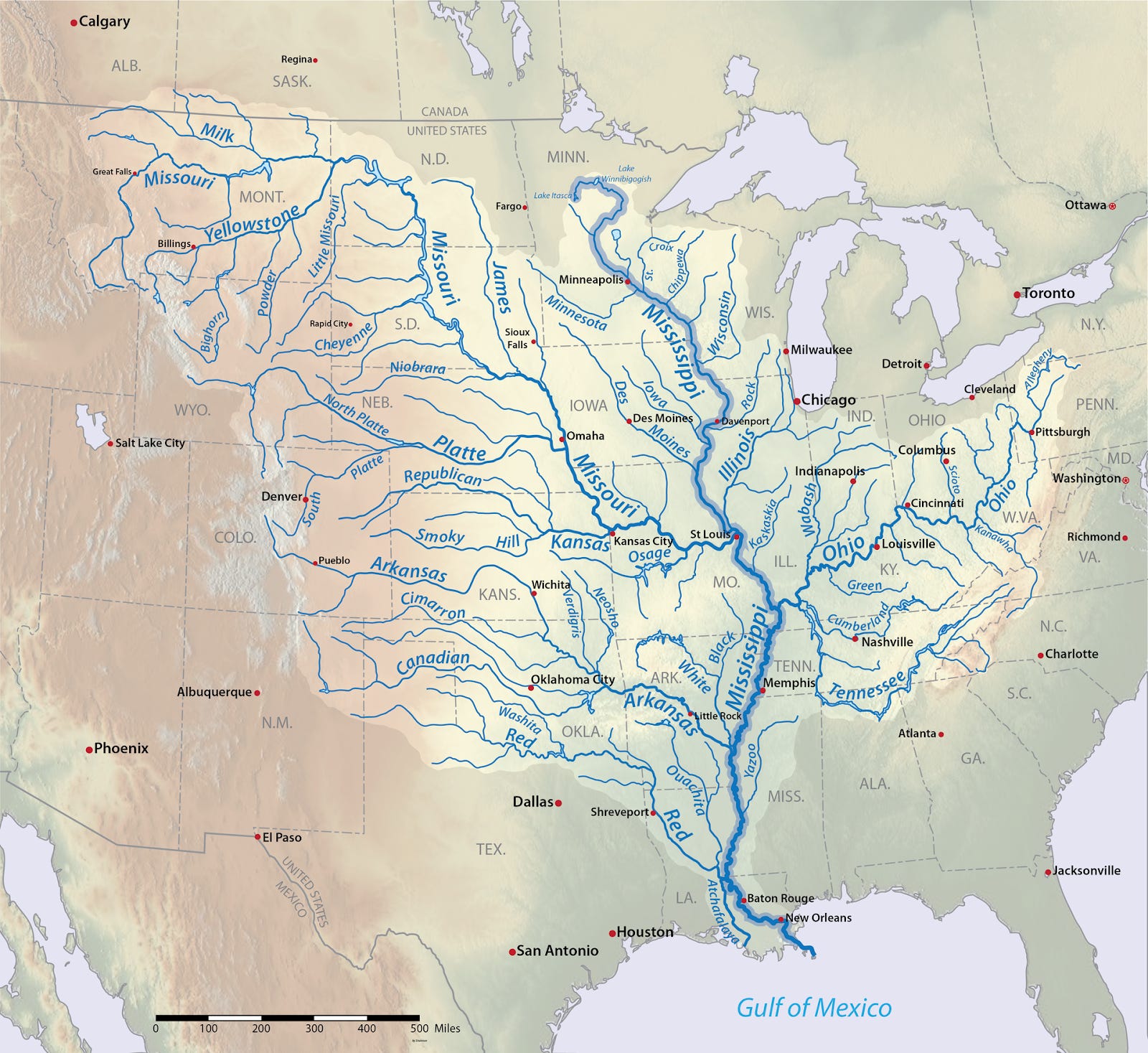
The Mississippi river and its numerous tributaries in the US heartland Source: Wikimedia
The star performer that makes all of this possible is the Mississippi river. A river with a personality so unique, that it’s not an exaggeration to say, it is the reason the United States could punch way above its weight in its early years, despite being an inexperienced country in the new world devoid of a shared history, culture or technological prowess.
Or as I call it, America’s “River of fortune”.
At first glance, the Mississippi does not seem extraordinary. It isn’t the longest, or the largest river by discharge volume, nor does it sustain mysterious rainforests like the Amazon teeming with undiscovered species. (The longest American river would be the Missouri).
But… It is navigable. Not just a few sections, but all of it. This makes it the longest navigable river system in the world.
To those unfamiliar, this leads to some pretty incredulous-sounding outcomes not possible anywhere else in the world. You can load thousands of tons of corn, soy and grain in St. Paul, Minnesota - 1000 miles (1600 km) from the ocean - onto a floating barge in the Mississippi river and make a nearly 2000 mile (3200 km) uninterrupted journey to the Gulf of Mexico. From there, you transfer the cargo to oceanic ships that travel to China and customers worldwide. The entire journey from the river to the ports on the other side of the planet barely touches land. The Mississippi lies squarely on the Midwestern farmland, so most of the agricultural output travels only short distances to get to the river. No other river system in the world compares in its reach, proximity, and sheer convenience as the humble Mississippi. But why the river? Because water is the cheapest form of transportation. As anyone who’s done rafting, you know how little paddling it takes to go downriver with the currents. A single barge can carry cargo equivalent to 70 large tractor trailers, at around 10 times lower fuel costs. That is how millions of tons of produce comfortably travels downriver from the Midwest to the ocean ports in the Gulf of Mexico. What goes down must also come up. Barges take grains and other industrial output for export downriver, and bring back imported cargo such as fertilizers and coal upriver.
Despite nature’s rare gift, keeping this system operational takes work. The Mississippi river is muddy and carries a lot of sediment from the fertile lands of the Midwest. It deposits most of this sediment in the river beds and ports. The sediments often build up and reduce the river depth. Since you need more depth to float heavier vessels, this means less water to float the gigantic barges that carry thousands of tons. In these cases, barge companies reduce the weight carried so that they can float, but the operating cost of the barge - including fuel - does not correspondingly reduce.
Often, a fully loaded barge can’t float further, if the depths are insufficient at certain segments in the river. To avoid this, the US Army Corps of Engineers (USACE), which manages all US waterways, frequently dredges the river to keep the depths to industry requirements. It costs money, but not shipping goods that are a vital cog in the global food and energy supply chain would cost even more. So far, so good. This system has worked well for the past century.
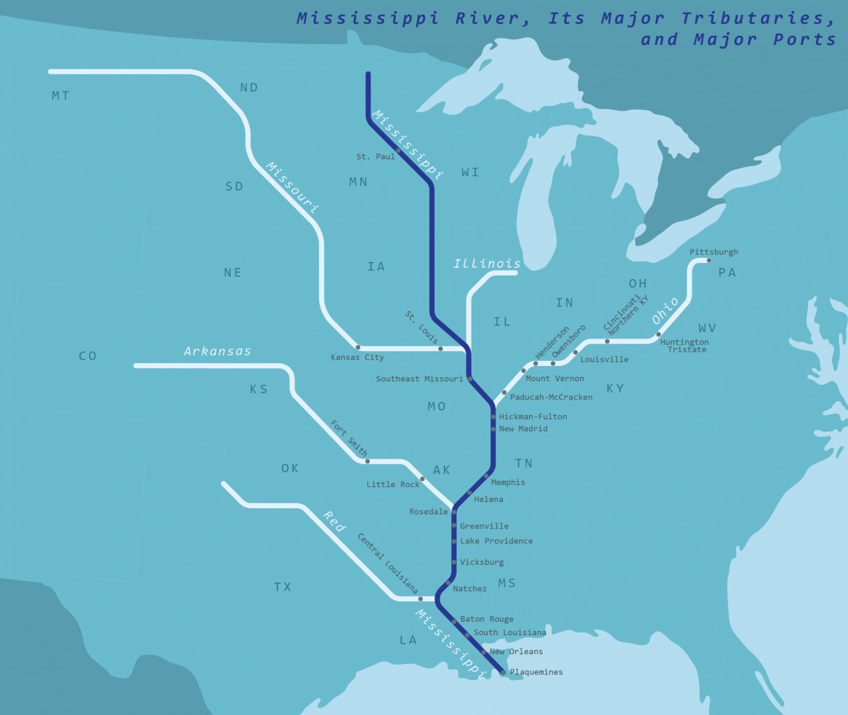
Panel 1: Mississippi river ports for inland waterway shipping. The river and its tributaries are used to load grain from the farms and ship it directly to New Orleans - the ocean. Source: US-BTS
We have reached the point where you wonder if we have any “bad” news. Oh, we do.
Climate Change has entered the chat
Like most nice things ruined by climate change, the Mississippi river is no exception. Climate change does two things to any river system: either it floods or it dries up. It’s not a binary distinction, since most rivers face one effect more often than the other. It’s 2022 - just ask the Italians about the Po river. Or the Germans about the Rhine, which lacks the depth to float the barges that drive their highly export-dependent economy. In the twisted climate change lottery, where there are no winners, the Mississippi river seems to have drawn the “flood” card. You might be cautiously optimistic that, for floating, more water is always better than no water.
Well, there is always too much of a good thing.
While it is damned hard to float 2000 tons when you have less water, it is unequivocally dangerous to float on high water levels caused by flooding. Floating upriver against these fast currents and unstable swirling eddies requires a lot more fuel (therefore, higher costs and higher emissions). But if you are floating with the current downriver, you are playing real-life Need for Speed with your barge (call it “Mississippi Drift”?). Each barge moves thousands of tons of grains, fertilizers, petroleum and coal. Barge captains try to avoid operating in these treacherous conditions, because of the immense risks involved with control at unsafe speeds. Capsizing or losing this cargo in the water would be an ecological nightmare. Millions of people and wildlife along the Mississippi rely on it for agriculture, water supply and industrial facilities.
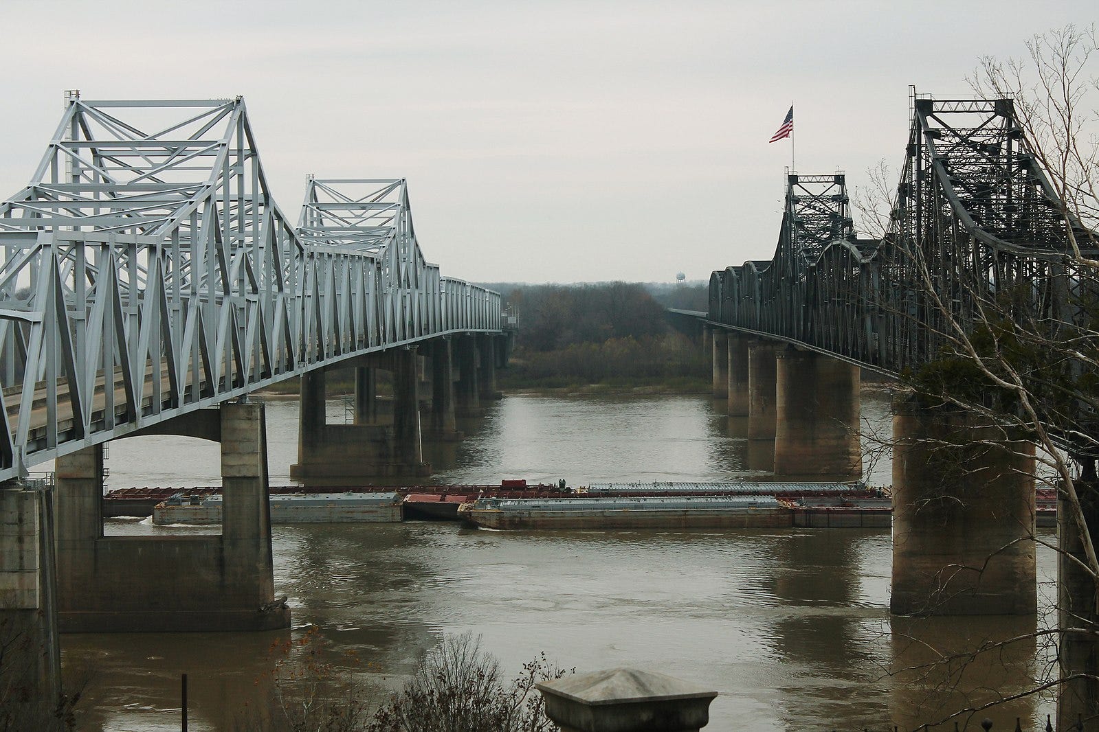
Even if you find a captain crazy enough to Jack Sparrow their way, they would be promptly introduced to the many bridges that cross the river. Bridges that your barge must pass under, not over, which is a distinct possibility during high water levels.
For all its convenience, what makes river transportation painful compared to every other form of transport is its binary quality. It is all or nothing. If you float 1000 miles from point A to B, either every mile is fully navigable, or none of it is. Unlike road or air transport, you cannot take a different route when there is an obstacle, or fly around bad weather. If there is anything stopping your barge, you are stuck. Rivers are nature’s interstates with no exits (and much like the human interstates, even had an obligatory McDonalds on the river).
In summary, if the Mississippi has high water levels beyond the safe limit, the millions of tons of goods that power the global supply chain aren’t going anywhere. To avoid this, the USACE maintains a sophisticated system of locks and dams to maintain levels when there are deviations. But they can only go so far. While the heavily engineered system is a technological marvel in its own right, like most civil infrastructure today, they built it decades ago. They designed it for operational parameters in a climate that no longer exists. What the designers considered outrageous levels of rain and flood then, is reality now.
None of this is theoretical speculation.
Sleepless in Mississippi
In 2019, the USACE closed river transportation between Baton Rouge and New Orleans, Louisiana because of high, dangerous water levels caused by flooding. This caused an estimated $295 million loss per day, with millions of tons of grains not leaving the port and, most times, rotting. The US supplies a whopping 35% of the world soy supply, and 32% of corn. The world uses these for food and feeds for livestock and meat industry.
And more than half of this floats down the Mississippi.
Then there is petroleum for domestic markets, coal for power plants, and fertilizers for agriculture that cannot make it to places that desperately need it. It took more than a year for the agricultural sector to recover from a single shock to the system at a single location. At one bottleneck, 300 barges were stuck. Thousands of tons of corn meant for the food supply chain were at risk of spoilage. Desperate farmers instead diverted them by road and rail to the biofuel plants for ethanol production.
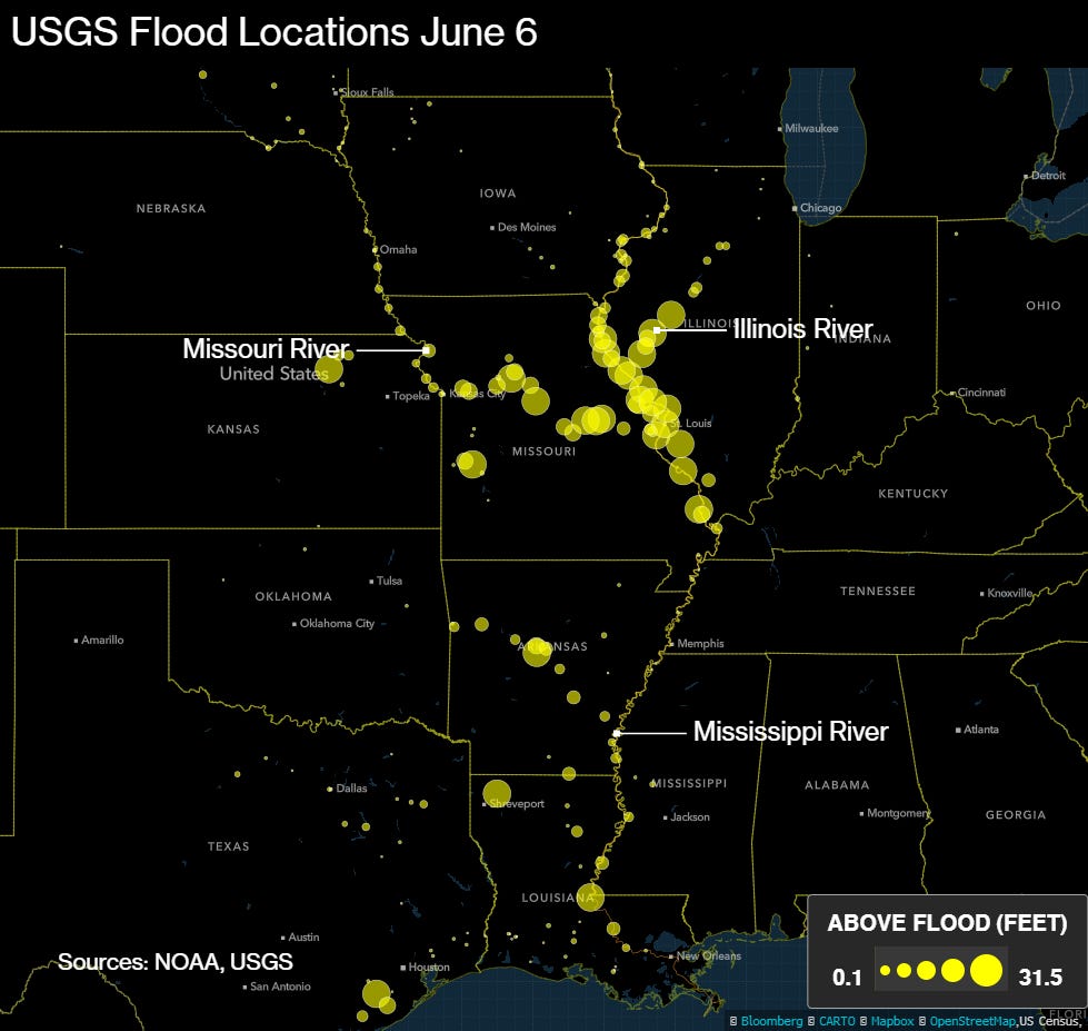
Flooded locations along the Mississippi waterways in the Midwestern farm belt, June 2019.
Crucially, even though climate change impacts make Mississippi more likely to flood, it doesn’t mean it always does. Case in point, another economic disaster in 2012 caused by shipping delays in the Mississippi was because of drought. The drought in the Midwestern region didn’t produce enough precipitation to keep water levels on the upper Mississippi navigable, even though the lower Mississippi was open to pass. As a result, the waterways were closed 3 times, and the overall compounded economic losses amounted to $35 billion.
The year before, in 2011, saw floods. Estimated damage: $3.4 billion.
Talk about swinging between extremes. These wild mood-swings of nature are often called climate whiplash. Climate science is often about broad trends, rather than specific absolutes. While it cannot tell us exactly how much it will rain in a city 5 years from now, it can tell us if it will rain more or less. Therefore, it is crucial to look at recent data from this perspective, to get a sense of our future. One key metric in interpreting such data from recent years is “Departure from Normal Precipitation”. In climate jargon, it is a measure of how much more, or less, it has rained (or snowed) compared to the baseline - or average - for that region. How do you know what the average is? With the US, it is the time range from 1981 to 2010. Below, we see the precipitation trends for the last 5 years.
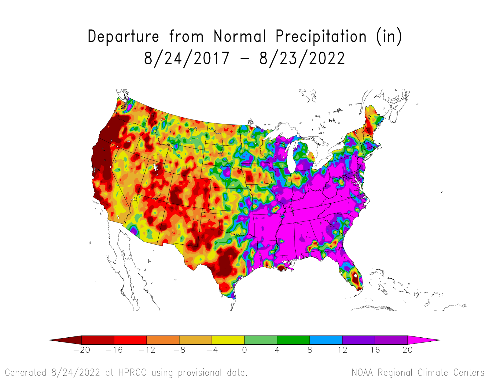
Precipitation in the US for the last 5 years (2017-2022) exceeding the normal trend (1981-2010) shows the Mississippi region getting vastly more precipitation, and the US west getting much less. Source: US NOAA
There is a lot to unpack here. Texas is getting drier by the year, while half of Florida is getting drenched, except for the southern tip. California and Oregon are living in an alternate water-free dimension. But for now… See the enormous patch of eye-popping pink? That is smack on the Mississippi river, the Midwest, most of the east coast and the southeast. In the last 5 years, most of the river and the land surrounding it have seen an excess of 20 inches rain from what is normal for the region3. This means a direct increase in water levels, leading to frequent interruptions of barge movements. And the 2019 event? Here is a quote from the Director of USACE, Tom Heinold, at a section of the upper Mississippi, during that crisis4:
We don’t know what normal is anymore. It used to be, 15 or 20 years ago, that a flood was the exception. The extremes seem to be the new norm.
More floods mean more sediment dumped into the river bed. The USACE must remove it so that barges can move without getting stuck. The extreme weather means it is already costing millions of dollars more to dredge. The cost increase is being passed on to the consumers, and there are no signs of improvement.
This is the present. Let’s look at what the future holds.
Well-behaved Rivers Seldom Make History
So how frequent will the Mississippi floods be? Can we have clear estimates for how many feet we expect the water to rise? These are consequential questions if the river continues playing its decisive role in the global food and energy supply chain. We know the trends we are already experiencing will get worse, but exact, quantitative answers are not forthcoming. This is a scientific problem. Recent academic literature is sparse on the topic, which does not consider data from the recent years, when things have taken a turn for the worse.
(That even scientists haven’t gotten around to this - and they study everything - shows how much we have taken our nature-dependent supply chains for granted).
The precise impact of climate change on the Mississippi river is notoriously hard to investigate. Since the planet is warming, the average temperature is increasing around 1-3 Fahrenheit on average everywhere in the US, according to the NOAA. Other deciding factors are climate phenomena like the famous El Niño5 and La Niña, which affect global rainfall and weather patterns every few years. Finally, there is the big human factor, whether we will decrease or increase our emissions, since that will influence how the climate responds. The calculations now become a tug-of-war between several competing factors. Scientists summarize the outcome into two broad forces:
On the one hand, more warming means more evaporation of water on land. Water that will not enter the river. Also, more warming means reduced snow. Meaning lesser snow will melt into water during Spring and enter the river. This is important since Missouri, the largest tributary of Mississippi, originates in the Rocky mountains. These events lead to less water in the Mississippi overall. This force points to a drier Mississippi.
On the other, increased warming heats the air, and hot air holds extra moisture. More moisture evaporates from land due to increased temperatures. Air with high levels of water content causes more rain, and therefore more water flows into the Mississippi. This force points to a wetter Mississippi.
What we do not know yet, is which force is more likely to dominate, and by how much. The last 10 years have seen both unprecedented extremes in water levels. If you stare enough at the precipitation map, you see it rained an awful lot more in the southern part of the river, while the northern stretch of the river has seen much less rain. Yet, northern Mississippi had drought in 2012 and floods in 2019, showing how complex it is to predict the results of these competing forces. The Mississippi is a river that flows from north to south. If recent trends are any sign, expect scenarios where the Mississippi is dry in the north, while flooded or normal in the south. At the same time. Recall the binary character of river transport: if your cargo has to reach the ocean ports in New Orleans, safe water levels are non-negotiable. All or nothing.
If you feel this is all counterintuitive and complicated, you are correct.
Earth and climate science are so devilishly difficult not only because physics is hard, but because we do not know how various competing forces interact. Each force can be convincing in its own right, while leading to directly opposite conclusions. This makes extending qualitative predictions to exact number-crunched forecasts tricky. Science is trying to catch up before we find out the hard way. This year, the US National Science Foundation (NSF) awarded a multi-year grant to Rice University to study what is in store for the Mississippi river by precisely answering these scientific questions. I will follow any scientific publications out of this project with great interest.
The Big Picture
The Mississippi river transports many goods, with a significant proportion being agricultural and energy raw materials. We tend to not appreciate these ancient natural arteries that enable the globalized economies of scale today. It’s easy to forget this amid the hustle and bustle of S&P 500, self-driving cars, the crypto-boom, and whatever the heck Web 4.0 is. Nature is increasingly taking a break from being charmingly predictable and nice (Which is understandable, considering our not so nice treatment of the planet). Initial forecasts of the Mississippi climate change scenarios show manageable levels of flooding if we reduce our emissions in the next few years6. Higher emissions are going to increase flooding beyond what the current system of river engineering can handle. Upgrading the system will take a lot of time, lot of money, and multiple disruptions to the supply chain. It is possible to avoid the worst if we can a) Reduce our emissions, b) Better scientific predictions, and c) Build the next generation of river engineering and flood control systems for our new climate reality. I would consider even accomplishing two of the three as a massive achievement.
The details in this article belies the disturbing statistic that most of the Mississippi river supply chain is to feed the world, not the United States. The supply chain that must cross the ocean. The fast and economical way to do it right, as it has always been done, is down the Mississippi.
We have seen how the Mississippi river is affecting our ever-so-fragile supply chains. So far, we have pretended that the “supply” part of the chain, the agricultural bounty from the Midwest, is a gift that will keep on giving. A gift that is caressed, nourished and ultimately enabled by the Mississippi. A Mississippi that is getting a little… antsy.
Well, there will be changes. Changes that will raise eyebrows everywhere in the world. Especially in the large number of countries that import their food. Particularly with a large, Pacific-facing nation in Asia, that America seems to be not so chummy with these days. Also, with a bare-chested, horse-riding tin-pot megalomaniac who, unfortunately, has a lot more to say on this subject than we would have liked.
In my next article, the humble Mississippi meets the world.
If you made it this far, thank you for reading the introductory post of Climatonomics! As a young newsletter, your support matters a lot in producing more quality researched content. Please subscribe and share your feedback in comments!
UN Food and Agriculture Organization https://www.fao.org/faostat/en/#data
UN Food and Agriculture Organization https://www.fao.org/3/u8480e/u8480e07.htm
At the time posting this story, the Pearl river in the United States is flooding due to heavy rains
Unable to find the original source, possibly due the original report’s website being inaccessible/under maintenance at the time of this writing. If you authored this interview, please reach out with the source and I will reference you here.
Munoz, Samuel E., and Sylvia G. Dee. "El Niño increases the risk of lower Mississippi River flooding." Scientific reports 7.1 (2017): 1-7.
NSF Grant 2022: https://www.nsf.gov/awardsearch/showAward?AWD_ID=2147781
Thanks for a well written piece on climate, agriculture, and transportation!
I would suggest several things flow from the ideas discussed here.
First, more discussion on dam safety in the US. There are many small dams build in theme 1900s in the Midwest and East Coast for industrial purposes that have huge amounts of contaminants in the sediment behind them. The NYT discusses some of that here.
https://www.nytimes.com/2020/05/21/climate/dam-failure-michigan-climate-change.html?smid=nytcore-ios-share&referringSource=articleShare
As part of my graduate research at the University of Michigan, I did a review and analysis of the dams along the River Raisin in Michigan. And looked at the inspection reports of many more. They were not built for the floods that are coming. And should one fail in the middle of a town... lots of people will be in danger even after the waters go down.
Pa is doing better with an aggressive review / permit process due to historical memories of Johnstown. But the change in rainfall will be an issue everywhere your map is pink.
And then those large waste impoundment associated with CAFOs are, as we’ve seen, are one hard rain from ecological disaster. They aren’t even built to the same standards as those Pa and Michigan dams.
My second thought is how many of those bridges over the Mississippi and tributaries would need to be raised to permit barge travel?
Let alone how many regular bridges over creeks, streams, and smaller rivers will need to raised or have their structures evaluated for scouring under increased flood levels.
The IIJA isn’t even close to providing enough funding to address those concerns.
Thirdly, the Army Corps has allowed flooding of land adjacent to the Mississippi to protect communities further down stream.. as well
As relocation of communities.
Finally, a quote from Mark Twain
One who knows the Mississippi will promptly aver—not aloud, but to himself—that ten thousand River Commissions, with the mines of the world at their back, cannot tame that lawless stream, cannot curb it or confine it, cannot say to it, Go here, or Go there, and make it obey; cannot save a shore which it has sentenced; cannot bar its path with an obstruction which it will not tear down, dance over, and laugh at.
True then and now.
Really interesting and clear. I would like to highlight how friendly and fun your style is regardless of the severity and the seriousness of the problematic addressed and the data analysis presented. I'm looking forward to see more.